
Our first little mini hike of the season was a huge success and had myself and the girls ready for more, but then life got in the way a bit. I had to prep for family visiting, making sure the house was clean and we had some post school things to take care of like dental and doctors appointments. You know… Life. But when family arrived from out of town, I was thrilled to find out that they wanted to adventure with us and head out for a hike. Always music to my ears!
Being that it was still early in the season and I was hiking with family, we decided to do a trail that rates as easy and, based on reports, was snow and mud free. Like I said, the heavy winter made for a long melt out and even though its already July, many trails still have snow on them. Luckily this one was snow free. For this outing, I chose Big Four Ice Caves. I had been eyeing this trail for a while and it’s rated by most hiking sites as easy. It’s located off of Mountain Loop Highway, one of my favorite scenic drives.
Mountain Loop is not open year round, generally closing at the gate at Deer Creek after the first snow fall in October to November and opening again in May. This year, the road opening didn’t happen until Memorial Day weekend. During the closure, you can drive up to the gate at Deer Creek from Granite Falls or you can access a small section on the northern end just out of Darrington, but the main loop and unpaved portions are closed in the winter. Once everything melts out, its a gorgeous drive with access to more trail-heads and hikes. For those who love snow shoeing and other winter activities, you can park at the gate and walk to the trail-head and then up to the snow caves area, but the area is hazardous in the winter after heavy snow and especially in the spring due to avalanches. In the winter the caves aren’t even there as the spring and summer melt are what forms them. They disappear and then reappear every winter and spring.
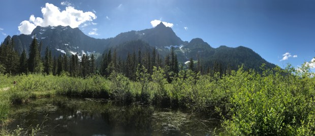
Big Four Mountain just out on the boardwalk from the picnic area.
The trail begins at two places, the official Big Four Trail-head and the Big Four Picnic Area. We parked at the picnic area and started off on the trail on this side. You cross over boardwalk through marsh ponds to the official trail. In the late Spring this area is generally covered in blooming skunk cabbage. Really pretty and really stinky but I find it to be worth the smell. Up until today, this was as far as we had walked on the trail.
After walking through the trees you come to a large bridge that crosses the Stillaguamish River. While the melt has subsided a bit, the river was running pretty fast, deep, cold and a gorgeous blue-green. I think we all stood here taking pictures and enjoying the scenery for a long time before finally moving on. After crossing the Stillaguamish, you make your way back into the forest, crossing Ice Creek over another footbridge and slowly begin winding your way up through the trees to the ice caves viewpoint. On a sunny day, the light coming through the forest canopy is just gorgeous and reminds me why I love hiking in Washington. The fallen trees and large root systems made for great places for the girls to explore and learn, often calling them fairy houses.


As you reach the top of the very gradual climb, you can see why hiking in this area during heavy snow fall or in Spring as the snow melts, can be dangerous. The forest disappears and the treeline grows short. You can see the many fallen and split trees left behind in the wake of a large avalanche. Keep in mind that the caves are created because they sit within a natural avalanche chute and the melting snow creates waterfalls and snow bridges that eventually turn into the caves that we see in the summer and fall.
Once we arrived at the viewpoint, we were greeted with the beautiful scenery of the tall mountains, multiple waterfalls cascading down the mountain sides and the caves. My photo opportunities weren’t great as people were climbing everywhere on the caves, despite the presence of an NFS ranger. Boy do I respect and admire the folks in the National Forest and Parks Service that have to deal with people who cant obey the numerous signs posted. I could explain the exact reasons climbing into the caves or on to the snow is a bad idea, but I wont.
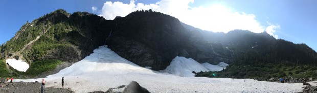
Ice caves panorama. Because of its easy tread and the fact that the hike is ADA accessible, its a popular spot! There were a lot of people at the caves today!
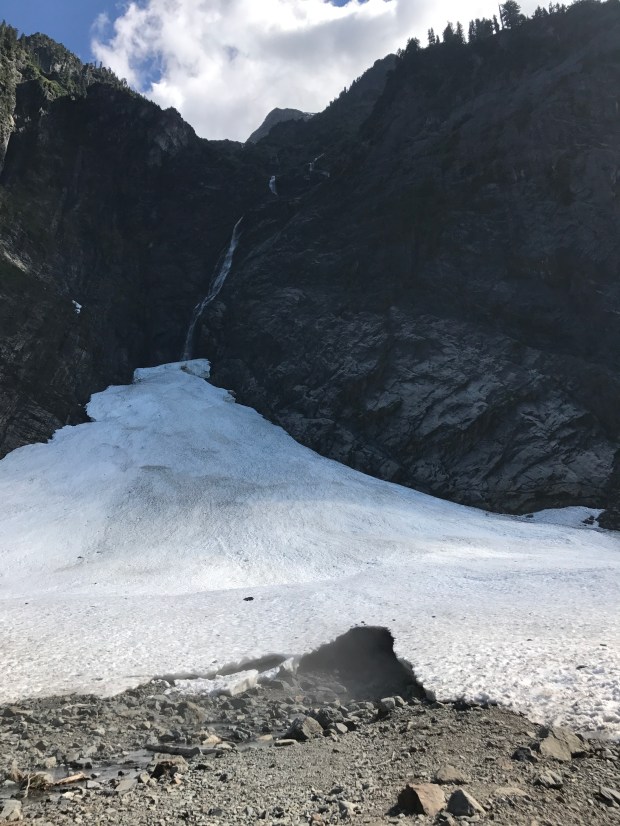
The Big Four Ice Caves… Only one was formed during our visit but I am sure in a month or so, there will be at least one more.
The girls had a great time at the caves and got a kick out of just how large they are. The pictures really don’t do them justice. My oldest loved that even standing a good 50 yards away, you could feel the cold blast of air coming out of the cave. A built in air conditioner on a warm July day!


After some exploration and pictures at the cave, we turned back and headed down to the trailhead for some snacks and a drive up to Barlow Pass and over the rest of Mountain Loop. It was a perfect day and I am so glad that we had the chance to get out and explore with family! Now I can check this one off of the list but I know well be back again, probably later in the season to see the caves when they have formed a bit more. Until then… Happy Trails!
XOXO – Jocelyn
Big Four Ice Caves Trail Stats
Difficulty: Easy
Length: 2.20 miles Round Trip, Out and Back
Elevation Gain: 220 ft
Rating: 4 out of 5
If this is a hike you might be considering, here are some tips about your visit.
* Whether you park at the main trailhead or the picnic area, be sure your car is locked tight and all valuables are taken with you. Despite its beauty Mountain Loop Highway is known for its troubles with break ins, theft and property damage. Only take what you need and keep it all with you. It has been suggested by rangers and Granite Falls police to keep your car registration, garage door openers and any items with your address on them with you in your backpack as well as keys, wallets, sunglasses, iPods, cell phones and anything that might pique the interest of someone looking for items to steal.
*As you leave Granite Falls, cell service is quickly lost for everyone. It does not matter which cell provider you have. The closest accessible phone, which is a pay phone, is found in Verlot at the Mt. Baker – Snoqualmie National Forest Ranger Station. Be sure that family and friends know your plans for the day including when you plan to be back and do not stray from that.
*DO NOT CLIMB INTO OR ON THE CAVES AND SNOW. Multiple deaths have occurred in the last few years due to to caves collapsing and people falling through ice bridges in the snow further up from the caves. It may look like solid snow but its not. STAY OFF AND OUT OF THEM.
